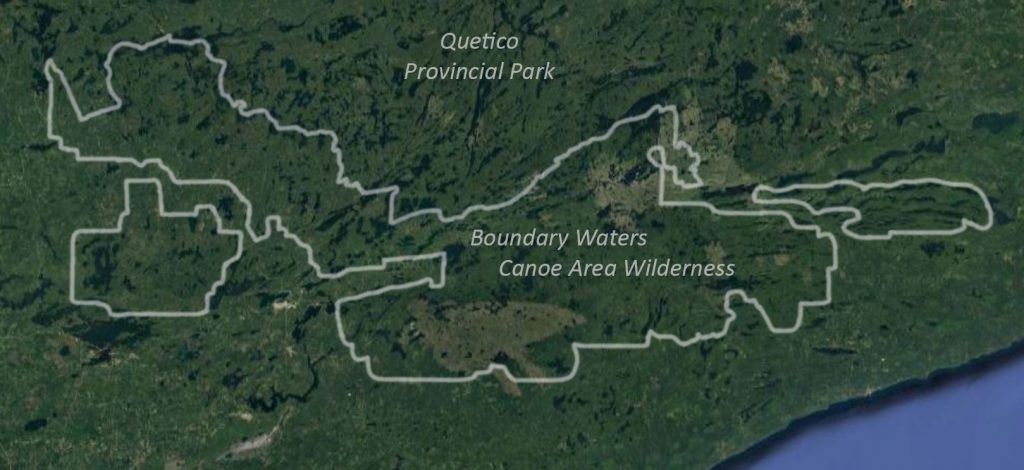
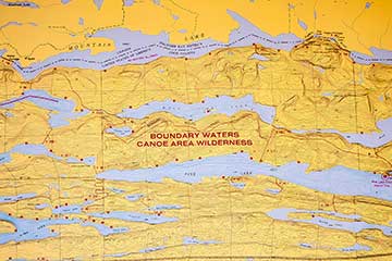
The Boundary Waters Canoe Area Wilderness (BWCAW or BWCA), is a 1,090,000-acre (4,400 km2) wilderness area within the Superior National Forest in northeastern Minnesota (United States) under the administration of the U.S. Forest Service. A mixture of northwoods, forests, glacial lakes and streams, it is a popular destination for both canoeing and fishing on its many lakes and is one of the most visited wildernesses in the United States.
Geology
The lakes of the BWCAW are located in depressions formed by differential erosion of the tilted layers of the Canadian Shield. For the past two million years, massive sheets of ice have repeatedly scoured the landscape. The last glacial period ended with the retreat of the Laurentide Ice Sheet from the Boundary Waters about 17,000 years ago. The resulting depressions in the landscape later filled with water, becoming the lakes of today.
Many varieties of Precambrian bedrock are exposed including: granite, basalt, greenstone, gneiss, as well as metamorphic rocks derived from volcanic and sedimentary rocks. Greenstone of the Superior craton located near Ely, Minnesota, is up to 2.7 billion years old. Igneous rocks of the Duluth Complex comprise the bedrock of the eastern Boundary Waters. Ancient microfossils have been found in the banded iron formations of the Gunflint Chert.
Forest ecology
The Boundary Waters area is within the Laurentian Mixed Forest Province (commonly called the “North Woods”), a transitional zone between the boreal forest to the north and the temperate hardwood forest to the south that contains characteristics of each. Trees found within the wilderness area include conifers such as red pine, eastern white pine, jack pine, balsam fir, white spruce, black spruce, and white-cedar, as well as deciduous birch, aspen, ash, and maple. Blueberries and raspberries can be found in cleared areas. The BWCAW is estimated to contain 455,000 acres (1,840 km2) of old growth forest, woods that may have burned but have never been logged. Before fire suppression efforts began during the 20th century, forest fires were a natural part of the Boundary Waters ecosystem, with recurrence intervals of 30 to 300 years in most areas.
On July 4, 1999, a powerful wind storm, or derecho, swept across Minnesota, central Ontario, and southern Quebec. Winds as high as 100 miles per hour (160 km/h) knocked down millions of trees, affecting about 370,000 acres (1,500 km2) within the BWCAW and injuring 60 people. This event became known officially as the Boundary Waters – Canadian derecho, commonly referred to as “the Boundary Waters blowdown”. Although campsites and portages were quickly cleared after the storm, an increased risk of wildfire due to the large number of downed trees became a concern. The U.S. Forest Service undertook a schedule of prescribed burns to reduce the forest fuel load in the event of a wildfire.
The first major wildfire within the blowdown area occurred in August 2005, burning 1,335 acres (5.40 km2) between Alpine Lake and Seagull Lake in the northeastern BWCAW. In 2006, two fires at Cavity Lake and Turtle Lake burned more than 30,000 acres (120 km2). In May 2007, the Ham Lake Fire started near the location of the Cavity Lake fire, eventually covering 76,000 acres (310 km2) in Minnesota and Ontario and becoming the most extensive wildfire in Minnesota in 90 years. In 2011, the Pagami Creek Fire ultimately grew to over 92,000 acres (370 km2), spreading beyond the wilderness boundary to threaten homes and businesses. Smoke from the Pagami Creek Fire drifted east and south as far as the Upper Peninsula of Michigan, Ontario, Chicago, Poland, Ukraine, and Russia.
Fauna
Animals found in the BWCAW include deer, moose, beaver, timber wolves, black bears, bobcats, bald eagles, peregrine falcons and loons. It is within the range of the largest population of wolves in the contiguous United States, as well as an unknown number of Canada lynx. It has also been identified by the American Bird Conservancy as a globally important bird habitat.
Woodland caribou once inhabited the region but have disappeared due to predation by wolves, encroachment by deer, and the effects of a brainworm parasite carried by deer which is harmful to both caribou and moose populations. Very rare sightings have been reported in nearby areas.
Regions
Overview:
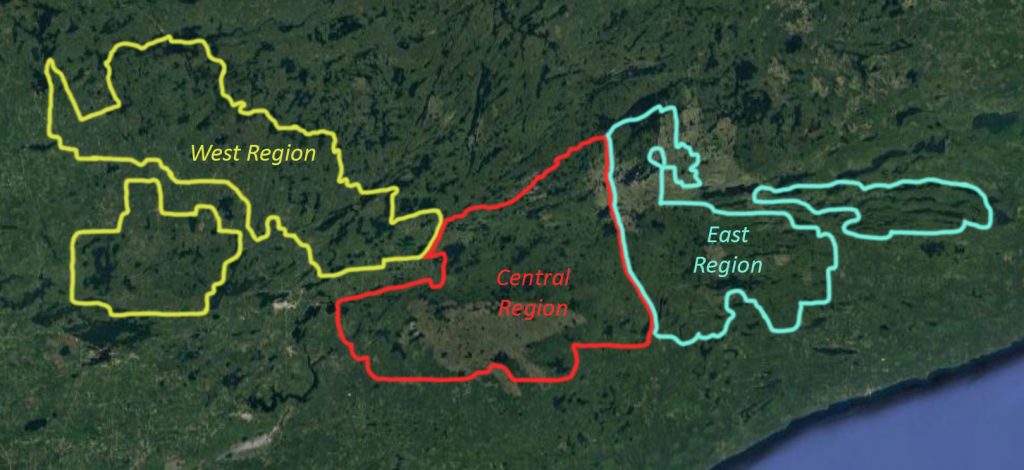
The Boundary Waters Canoe Area Wilderness is over 1 million acres of untrammeled woods and water stretching across three large counties in Minnesota from Lake Vermillion on the west side to almost the tip of the arrowhead on the east side. The area it covers is roughly 110 miles from west to east and 40 miles from north to south, though it is not a perfect rectangle by any means you get the idea. This large expanse from west to east leads to some differences between the specific regions, and though changes aren’t huge from one region to another if you know what some of them are it may help you decide on where to start your next trip from.
Typically, any discussion about where to enter the wilderness on your Boundary Waters canoe trip starts with deciding to go in through Ely on the west side or Grand Marais and the Gunflint Trail on the east side. Though breaking the BWCA into west and east makes sense we feel there are enough differences within the eastern or western halves to further describe some of the “sub-regions”.
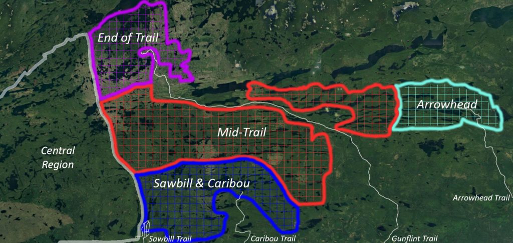
Considering our location and familiarity with the eastern half of the BWCA we will be starting by breaking down some of the differences between the sub-regions in that area first; as we see them.
From the 56-mile scenic byway known as the Gunflint Trail one can access 19 different Boundary Waters paddling entry points and we will start at the “end of the trail” and work down.
“End of the Trail”
Entry points: 50 – 51 – 52 – 54 – 55 – 57 – 80
Area Highlights: World Class Fishing – River Routes – Great Base-camping – Endless Route Options– Excellent Wildlife Opportunities – Shorter but Numerous Portages – Trails End Campground – Kayak Friendly
Things to Consider: Watch the Wind – Recent Wildfires in the Area – Motorboats on Saganaga and Parts of Seagull Lake
At some point during your trip to the lakes at the end of the trail you will encounter prominent signs of past wildfires, this will most likely happen at your entry point. This area has been affected by multiple fires over the past 20 years with the most recent and extensive one being the Ham Lake Fire in 2007, with Alpine, Red Rock and Sea Gull Lakes being the most noticeable. Over the course of these wildfires the efforts to maintain the integrity of the designated campsites has kept most of them in their original form. You will find most of the campsites in this area as they were before the fires, but surrounded by younger growth trees. Don’t let the remnants of old fires scare you off though as the lakes at the end of the trail offer some of the best fishing in the state and the vast majority of the islands and their excellent campsites on Saganaga were unaffected and still hold some of the oldest trees in the state. It has been ten years since the last fire and the area is greener than ever and though it may not be the picture perfect BWCA experience you have in mind it is a natural part of the evolution of the forest and an interesting look at how it is continuously changing. Old burn areas are the best place to look for blueberries and spy a moose. Regardless of the look entry points 54 and 55 will allow you to access the historic border waters that were paddled by the French Voyageurs, the excellent fishing on the South Arm of Knife Lake and Quetico Provincial Park. The large quota of permits for both of these entry points means you can almost guarantee one will be available, even on short notice.
Saganaga and Seagull Lakes are well known for their world class fisheries (the state record walleye is out of Seagull lake) and a trip to the end of the trail with a basecamp on either of these lakes would make for a perfect BWCA trip if fishing is your top priority. If you’re not base camping, entering at Saganaga (#55) or Seagull (#54) is the best place to start a big loop style trip out to the South Arm of Knife or beyond. Even if you’re not going to be spending the night in the park Trails End Campground is an excellent place to car camp and take day trips from.
Down the trail a bit from Trails End Campground you will find Round Lake Road which has three entry points off of it: Cross Bay Lake (#50), Missing Link Lake (#51), and Brant Lake (#52). The Brant Lake entry point requires the most paddling to get out of the old burn areas, with Missing Link and Cross Bay having little to no evidence of past wildfires, although you will paddle right past the campsite where the Ham Lake fire originated through the Cross Bay entry point. The lakes west and south of Round Lake Road are going to be smaller and more numerous than the lakes around Trails End Campground, but then again just about every lake is smaller than Saganaga. With the exception of the 435-rod doozy of a portage from Missing Link to Tuscarora you will find shorter portages and much more moving water between the lakes than anywhere else on the Gunflint Trail. There are two proper river routes within the BWCA on the Gunflint Trail, the Granite River and the Frost River and the Cross Bay Lake entry point is the best one to use for the Frost River. You could use Missing Lake as your jumping off point but the river flows in a clockwise direction so you can take advantage of that a little bit more by starting on the east side and working back around to the west and ending at Round Lake with a short walk back down to your vehicle at the Cross Bay parking lot. The Cross Bay entry point is the most popular of the three so consider reserving one as early as possible, but for whatever reason there are almost always permits available to enter at Brant Lake. If you’re visiting the BWCA specifically for the wildlife look no further than the Frost River. Whether it swims, stands or flies the incredible amount of wildlife that calls the Frost River and surrounding areas home is second to none. The time of year and current water conditions do affect some of the paddling and portaging in the area (especially the Frost River) more so than others so it is advisable to check with a local outfitter on conditions before heading out. Whether it’s a point A to B, loop or basecamp style trip you have in mind, the different route options within this area are almost endless.
Between Gunflint and Saganaga Lakes you will find the Granite River route which is one of only two true river based paddles on the Gunflint Trail. What makes it even more unique is that it is a larger river than the Frost and can be paddled almost throughout the year. Don’t get too excited about this being some kind of a lazy river that you get to float down with coolers of beer tied to your canoe experience though, because it most definitely is not. In fact, there are only a few spots on the entire stretch that you get to take advantage of current and the second half of the route is mostly lake paddling. You will feel the current much more on the first half of the trip with some spectacular portages around waterfalls and rapids. This route is above the Laurentian Divide which means all of the water flows north to Hudson Bay which is a direction most people are not used to seeing a river flow. Though you could paddle this in either direction but it will be much easier to go with the flow so entry point #57 and putting in at Gunflint Lake will be the best place to start. If you wanted to go rogue and paddle upstream you would want to use entry point #55 Saganaga Lake. Unfortunately, this is another area that was hit hard by the Ham Lake fire in 2007 and the results are still very evident throughout the entire route. As with almost all of the other lakes affected by that fire almost all of the campsites were preserved during the fire. If you are looking to add on even more of a river experience to your Granite River trip or if there are no permits available, consider using entry point #80 Larch Creek.
“Mid-Trail”
Entry Points: 47 – 48 – 49 – 58 – 60 – 61 – 62 – 64 – 66
Area Highlights: Smaller Intimate Lakes – Common Moose Sightings – Great Walleye Fishing – Easy Access – Nice Campsites – Great for Beginners
Things to Consider: Very Popular – Can get “crowded” in the summer
Half-way up the Gunflint Trail you will find Poplar Lake and the lakes that make up the Mid-Trail sub-region. Poplar Lake itself is entirely outside of the Boundary Waters Canoe Area and though it has multiple resorts, restaurants and private cabins on its north shore and even some of its islands it still feels like the wilderness. The lake is your jumping off point for each of the three entry points that lead into the park; Swamp and Lizz Lakes, Meeds Lake and Skipper Lake. Entry point #47 Swamp and Lizz Lake is one of the most popular on the entire Gunflint Trail because it is by far the easiest of the options to enter the BWCA from Poplar. A permit for #47 allows you to enter through Lizz or Swamp and the two short portages through Lizz into Caribou is a much easier option than the two 150+ rod portages through Swamp, unless you want to stop for some excellent Walleye fishing on Swamp. A permit through #48 Meeds Lake will essentially get you into the same area as #47 but it requires a 320 rod portage (that’s a mile). The last entry point off of Poplar Lake is #49 Skipper Lake and though it won’t allow you to access the same lakes as the previous two entry permits it will put you into some quieter lakes and is typically a permit that is available on short notice. By now you should realize there is a reason that certain entry points have permits available all the time, and that is almost always due to the difficulty involved in getting to and entering the specific entry point. Getting to Skipper Lake requires a mile-long portage off of Poplar or you drive a bit farther and put in at Portage Lake and come down from the north, but that is probably just as much work.
The lakes west of Poplar in the Mid-Trail area are smaller than average, bog-stained, typically oriented in a narrow west east fashion and connected by short portages, while the topography in the area is relatively subdued. This mixture of characteristics makes the area a great place to take your first BWCA trip. The short portages will keep you from getting too exhausted and the smaller lakes will make it easier to contend with the wind if it picks up. The fishing in the area is pretty decent too, and the best lakes are the ones closest to Poplar, with Caribou, Horseshoe, and Swamp as your best walleye lakes. Farther west you will run into some larger waters that hold lake trout and big northern pike. While there are multiple small loops and one large one that can be put together through these entry points most people base camp and explore the area. This area makes for a great beginner trip but keep in mind that it is very popular and you may want to weigh other options if you’re trying to avoid “crowds”, especially in July and August.
“Sawbill & Caribou Region”
Entry Points: 41, 43, 44, 45
Area Highlights: Great Rainbow & Lake Trout fishing, secluded areas, available permits.
Things to consider: Some steep and long portages, more remote, secluded, and rugged than other parts which leads to having frequently available permits.
The Sawbill & Caribou Region is so named because of the two main trails that lead into it. While it is accessible through the Gunflint Trail, it’s more directly accessed by these other trails. Including lakes such as Brule, Swan, Bower Trout, and Morgan Lake it’s known for its more secluded and rugged atmosphere. Brule Lake is a large lake with easy access and a lot of great campsites. The lake itself is very popular but many routes out of the lake lead to seclusion. As such, starting off your trip at Brule you may see a few other paddlers, but as you get deeper and further into your trip chances are you’ll be by yourself. Bower Trout Lake is quiet due to the rugged portages between it and Brule Lake. A great option to “get away” is to portage out to Swan Lake and base-camp from there. Ram Lake has only one permit per day, which means you’ll most likely see very few people in the area. The access to the lake is a steep 90 rod portage. It’s a popular spot in the spring as it’s a great fishing lake for Lake & Rainbow Trout. You can also paddle the Poplar-Ram Route from this lake. Morgan Lake is very remote, requiring a 370 rod portage (over a mile) to get to it. Because of this there are almost always permits available. This is a great opportunity for you to get out and enjoy the wilderness truly to yourself. Be prepared to work for your serenity though, but anything worth having is worth working hard for.
“Arrowhead Region”
Entry Points: 68, 69, 70
Area Highlights: Very remote, long paddling, great walleye fishing.
Things to consider: Long driving distance, long paddling routes so you want to start early, can be windy.
The Arrowhead region is wonderful for those who truly want to escape from the monotony of the day to day. It is the Easternmost part of the BWCA and is accessible via the Arrowhead Trail. While it does take longer to drive up to the lakes, once you get there you won’t be disappointed. There are many large lakes, such as Pine Lake, which offer spectacular days on the water. You’ll want to start your days off early though as wind can be a major factor in determining how far you’ll be able to paddle. Once you’re on the lakes you’ll love the great Walleye fishing and beautiful scenery. Since the area is more remote you’ll almost always be able to claim a permit. This area is perfect for getting away.
While not technically part of the BWCA, there are other great areas to experience which are accessible from the Arrowhead Trail. Grand Portage is a historic site that was bustling during the North American fur trade era. They have a Junior Ranger program for kids ages 12+ that has the kids fill out an activity book. It asks them questions and invites them to learn more about the historic depot and surrounding area. It’s got a nice, gentle hike up Mount Rose that overlooks the whole area. There are stunning views of waterfalls and the historic buildings.
Greenwood Lake is another area that’s not part of the BWCA but is too good not to mention. It is a large lake, about 2,021 acres large, and about 112 feet at its deepest point. It’s wonderful for fishing and has a good variety of fish like Bluegill, Brook Trout, Green Sunfish, Lake Trout, Lake Whitefish, Smallmouth Bass, White Sucker and Yellow Perch. Because it’s not part of the BWCA motor boats are allowed on it via a gravel boat ramp.

