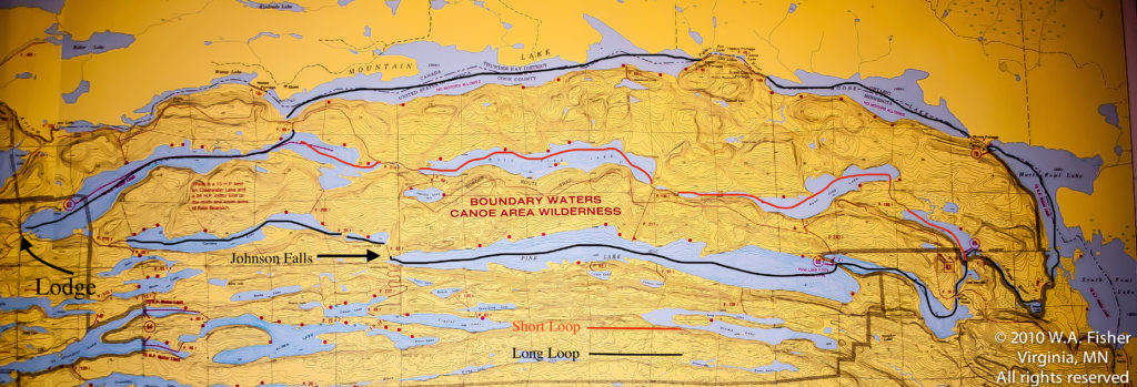
Clearwater Main Route
| Difficulty Levels |
Moderate — medium-to-large lakes |
| Route Times |
3 to 5 days – Approximately 37 miles |
| Lakes |
Clearwater, West Pike, East Pike, John, Little John, McFarland, Pine, Little Caribou, Caribou, Clearwater |
| Entry Points |
#62 Clearwater Lake |
| Route Highlights |
Scenic, good fishing, Johnson Falls, Border Route Trail |
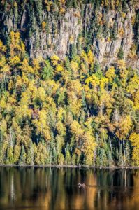 This area is referred to as the “Minnesota Mountains” for good reason. With crystal clear waters below and towering 400ft cliffs above, this incredibly scenic route will take you through some of the most unique lakes in the state. The Border Route Trail runs through the area as well with multiple spur trails which climb quickly to the tops of those towering cliffs, offering splendid views into Canada and beyond. Plenty of fishing options abound depending on what you’re looking for. Clearwater, Mountain and East and West Pike are great Lake Trout lakes in the spring.
If it’s Walleye you’re after Caribou and Pine lakes are tough to beat. Smallmouth Bass and Northern Pike can be found in good numbers throughout the entire area, and even a number of managed trout lakes holding Brook Trout can be found if you’re willing to work. No traveler to these parts should miss a visit to Johnson Falls; a pristine set of wilderness waterfalls which offers refreshing swimming holes and seclusion.
A longer loop can be made by traveling the Canadian border lakes East to North and South Fowl. Moose Lake is seldom visited and may be one of the best Lake Trout lakes in the state.
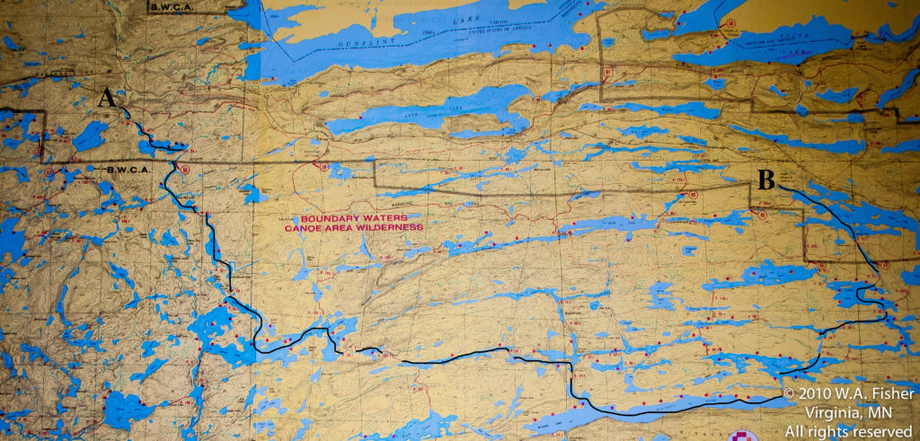
Cross Bay-Poplar Lake
| Difficulty Levels |
Moderate — small and medium lakes |
| Route Times |
4 to 6 days – Approximately 25 miles |
| Lakes |
Round, Ham, Cross Bay, Rib, Karl, Long Island, Muskeg, Kiskadinna, Omega, Henson, Pillsbery, Swallow, Meeds, Poplar |
| Entry Points |
#50 (40 minutes by shuttle) #48(15 minutes by shuttle) |
| Route Highlights |
Smaller lakes, wildlife, excellent fishing, dead-end lakes. |
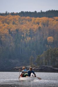 This route can be traveled in either direction, although with predominant winds from the west you may want to start at Cross Bay Lake. The option for calling for a pick-up from Trail Center Lodge on Poplar Lake also makes starting at Cross Bay Lake the better option. This is a great route for those wanting to cover some ground and paddle smaller lakes. Smaller lakes give more protection with wind. You’ll enjoy some river paddling south of Ham Lake and have some good wildlife opportunities. You will find plenty of Smallmouth Bass and Northern Pike throughout the route, though if you are looking for Walleyes the lakes south and west of Poplar Lake is where you should start.
There are many options to expand this route. Traveling north through Banadad and Rush Lakes will take you through quieter waters, while heading south through Winchell offers excellent campsites and Lake Trout fishing.
Granite River
| Difficulty Levels |
Moderate |
| Route Times |
3 to 5 days – Approximately 20 miles |
| Lakes |
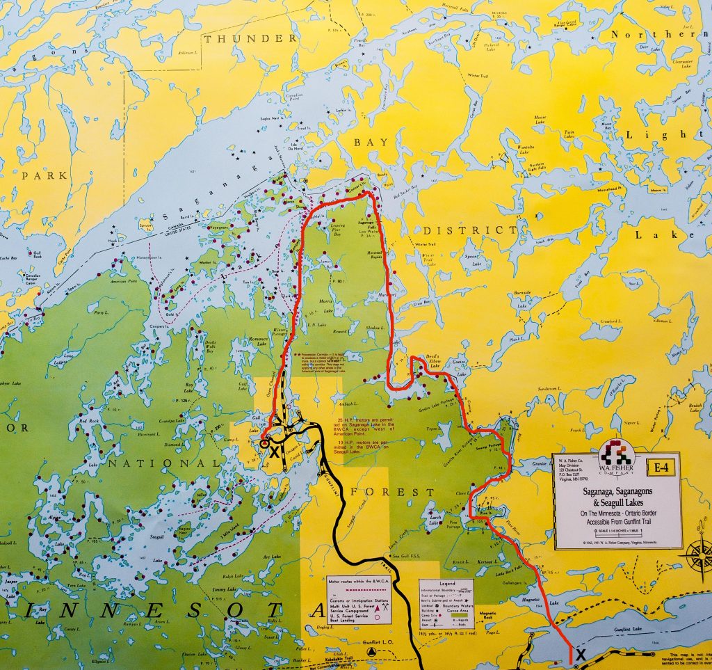
Gunflint, Clove, Gneiss, Marabuef, Saganaga |
| Entry Points |
#55- Saganaga or #57- Magnetic Lake (Preferred) |
| Route Highlights |
River Travel, Multiple Waterfalls, Short Portages, Unique |
The 13-mile stretch of river and lakes between Gunflint and Saganaga Lakes is known as the Granite River route and is one of the most unique in the area. Along with the Frost River route this is the only other river base canoe route on the Gunflint Trail. It’s waters flow north out of Gunflint Lake and the first part is the most intense with multiple portages around raging waterfalls and rapids. There are a couple of lakes that break up the river and this is where you will find most of the campsites and towards the end it widens out into essentially lake before dropping into Saganaga Lake. This area was subject to multiple wild fires over the years and its still very apparent, though most of the campsites have maintained their original integrity throughout. Although it flows south to north it would be best to start at Gunflint because there are a few sections where the current would be a bit of a challenge to paddle up.
 This area is referred to as the “Minnesota Mountains” for good reason. With crystal clear waters below and towering 400ft cliffs above, this incredibly scenic route will take you through some of the most unique lakes in the state. The Border Route Trail runs through the area as well with multiple spur trails which climb quickly to the tops of those towering cliffs, offering splendid views into Canada and beyond. Plenty of fishing options abound depending on what you’re looking for. Clearwater, Mountain and East and West Pike are great Lake Trout lakes in the spring.


 This route can be traveled in either direction, although with predominant winds from the west you may want to start at Cross Bay Lake. The option for calling for a pick-up from Trail Center Lodge on Poplar Lake also makes starting at Cross Bay Lake the better option. This is a great route for those wanting to cover some ground and paddle smaller lakes. Smaller lakes give more protection with wind. You’ll enjoy some river paddling south of Ham Lake and have some good wildlife opportunities. You will find plenty of Smallmouth Bass and Northern Pike throughout the route, though if you are looking for Walleyes the lakes south and west of Poplar Lake is where you should start.